Difference between revisions of "Getting to the space"
| (12 intermediate revisions by 3 users not shown) | |||
| Line 1: | Line 1: | ||
| − | + | {{Overview}} | |
| − | Nottingham Hackspace is located in Unit F6, Roden House Business Centre, Roden St, Nottingham, NG3 1JH. Beware, while the postcode does point to the right building on Google Maps, it doesn't correspond with our entrance, which is on the corner of Alfred Street South and Ashley Street. The H symbol on the map below shows this precisely: | + | Nottingham Hackspace is located in '''Unit F6, Roden House Business Centre, Roden St, Nottingham, NG3 1JH'''. Beware, while the postcode does point to the right building on Google Maps, it doesn't correspond with our entrance, which is on the corner of Alfred Street South and Ashley Street. The H symbol on the map below shows this precisely: |
| − | + | == Map == | |
{{#widget:OpenStreetMap|height=500px|width=100%|lat=52.9557|lon=-1.1350|zoom=17|poifile={{fullurl:Getting to the space/Points of interest|action=raw§ion=0&templates=expand&ctype=text/plain}}}} | {{#widget:OpenStreetMap|height=500px|width=100%|lat=52.9557|lon=-1.1350|zoom=17|poifile={{fullurl:Getting to the space/Points of interest|action=raw§ion=0&templates=expand&ctype=text/plain}}}} | ||
== Access == | == Access == | ||
| − | + | [[Image:Roden_House_-_Feb_2019.jpg|thumb|right|300px|The Blue door to the hackspace.]] | |
| + | {{main|Access to the Space}} | ||
| − | [[ | + | Street access the [[Hackspace 2.0|upstairs]] of the space is through the turquoise door on the south-east corner of Roden House. Go up the spiral stairs, then straight on when you reach the first floor. |
=== For people with disabilities === | === For people with disabilities === | ||
| Line 23: | Line 24: | ||
=== Car parking near the hackspace === | === Car parking near the hackspace === | ||
| − | There are on-street parking spaces right outside the Hackspace on Ashley Street | + | There are on-street parking spaces right outside the Hackspace on Ashley Street that are free for two hours between 8a.m - 6p.m, (but often are occupied by permit holders during the daytime). Other roads in the area have Pay & Display parking restrictions. [https://www.myringgo.co.uk/bookparking RingGo] is available on most of the streets with Pay & Display restrictions. |
Parking on Robin Hood Street and Stonebridge Road is restricted to residents 8a.m - 6p.m Monday - Saturday. | Parking on Robin Hood Street and Stonebridge Road is restricted to residents 8a.m - 6p.m Monday - Saturday. | ||
Revision as of 10:14, 20 March 2019
| Overview |
|---|

|
| The Space • Location • New Members • Tools • Events • Teams • Projects |
| Volunteering • Infrastructure • Network • Members • Action List • Donations Pledge Drives • Meeting • Financials Branding • Suppliers • History |
Nottingham Hackspace is located in Unit F6, Roden House Business Centre, Roden St, Nottingham, NG3 1JH. Beware, while the postcode does point to the right building on Google Maps, it doesn't correspond with our entrance, which is on the corner of Alfred Street South and Ashley Street. The H symbol on the map below shows this precisely:
Map
Access
- Main article: Access to the Space
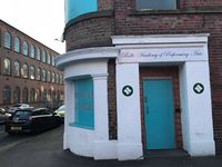
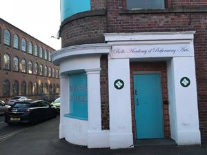
Street access the upstairs of the space is through the turquoise door on the south-east corner of Roden House. Go up the spiral stairs, then straight on when you reach the first floor.
For people with disabilities
The building has a goods lift that can provide access via the doors on the North side of Roden House. The 'Winners Gym' entrance.
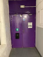
Once upstairs, the 'back door' to the upstairs workshop has been fitted with Gatekeeper RFID Access so it is possible to enter the space through the double width fire doors.
The goods lift
The goods lift is 5' deep x 6'1" wide x 7' high.
By car
Park and Ride
If you park at the Queensdrive park and ride you can take the Citylink 1 bus directly to Fletcher Gate (the buses always make a scheduled stop here). From here, follow the walking directions to the space.
Car parking near the hackspace
There are on-street parking spaces right outside the Hackspace on Ashley Street that are free for two hours between 8a.m - 6p.m, (but often are occupied by permit holders during the daytime). Other roads in the area have Pay & Display parking restrictions. RingGo is available on most of the streets with Pay & Display restrictions.
Parking on Robin Hood Street and Stonebridge Road is restricted to residents 8a.m - 6p.m Monday - Saturday.
If you're struggling to find on street parking there is a small pay and display car park between Longden street and Handel street (Sneinton Market Square)
The first hour is free - but you will still need a ticket, press the button on the ticket machine without inserting any coins to get the free ticket. After the first free hour, parking is £1 per hour up to 4 hours or £6 for 24 hours.
By Bicycle
There is space in the workshop for several bikes to be locked up. There is also a secure Nottingham CityCard Cycle Hub next to the Victoria Leisure Centre (less than 5 minutes walk from the hackspace). You will need a Nottingham CityCard which has been activated for Cycle Hub access to open the gate.
Bike Routes
The route shown is from the train station, as:
- It is expected that people may bring their bikes on the train
- From the station, it is necessary to cross or follow the A60, the main north/south road through Nottingham.
Note: The London Road (A60) roundabout can be very busy, and is very wide. It might be better to walk around it if you're unsure either of your route or your cycling skills, or follow the alternative route below.
This is the most direct route (Google Map):
Description:
- Turn right out of the station main entrace and right again onto Station Street (Alternatively, exit the station via the tram stop bridge and turn left onto Station Street)
- Go along station street to London Road (A60)
- Turn left along London Road (A60). Position yourself in the third or fourth lane (of four) for the roundabout.
- At the roundabout, you will be taking the second exit. You want to be in the third or fourth lanes (of four) leaving the roundabout.
- Exit the roundabout at the second exit. Stay in the third/fourth lane and turn right onto Fischer Gate.
- Cross over the A60 onto Pennyfoot Street. Continue to the next junction
- Turn left onto Manvers Street. Continue to the next junction.
- Turn right onto Southwell Road. Continue to the next junction.
- Go straight on (road turn slightly left).
- Take the third turning left onto Alfred Street South.
- At the junction with Ashley Street, you have reached the Hackspace.
- Alternatively, the route below avoids the roundabout and the A60 entirely (Google Map):
- Cross London Road (A60) using the pedestrian crossing just before the roundabout.
- Between the BBC building and the Premier Inn is the City Link road. Follow this road to the end, then turn left onto Manvers Street.
- Follow Manvers Street to the end (junction with Southwell Road).
- Follow the route from step 8 above.
By bus
The closest bus stops are on Carlton Road, just around the corner from the hackspace. The following bus routes will stop on this road: Lilac line: 24, 25, 27
An alternative is the route 39 to Carlton Valley, which has a stop known as 'Roden Street' on Robin Hood Street.
These buses run from the Victoria Centre (stop V1, outside Boots on the south side of the Victoria Centre). However, it is almost certainly quicker to walk to the hackspace from here than to get a bus.
If you travelling by bus from further afield, you will mostly likely arrive either at Victoria Bus Station or Broadmarsh Bus Station. In either case, it is quickest to walk from there. If you wish to get a bus:
- From Victoria Bus Station, walk through/around the Victoria Shopping Centre to stop V1 and get the Lilac Line (see above)
- From Broadmarsh Bus Station, get the City Loop bus to the Victoria Centre and change onto a Lilac Line bus (see above).
By train
Nottingham railway station is a twenty minute walk from the hackspace and has direct trains to these locations:
- Manchester in just under 2 hours
- London in about 2 hours
- Liverpool in around 2 hours 45 minutes
- Birmingham in about an hour
- Mansfield and Worksop
- Grantham and Skegness
- Sheffield and Leeds
- Derby
By boat
If you are travelling by canal, you can moor your narrowboat at Nottingham Castle Marina. From there it is a 20 minute walk to the train station along the canal. Follow the walking directions from here.
By air (Commercial)
Fly to East Midlands Airport and catch the Skylink bus, which stops outside the railway station and in Friar Lane. Follow the walking directions from here.
By air (GA)
Nottingham Tollerton (Nottingham City Airport) is the nearest GA airport, located to the east of the city. From here, you can get a taxi directly to the space, or walk into Gamston and get the Green Line numbers 5, 5A or 7 from the Morrisons. This bus will stop at the Lace Market and Victoria Centre. Follow walking directions from there.

